General Information of the Region
The Management Body of Kotychi and Strofylia Wetlands is a nonprofit private legal Entity, supervised by the Ministry of Environment, Energy and Climate Change.
It was founded in 2002 by National Law and it is governed by a Board of 11 members that represent central Government, all levels of local Government, Environmental Organisations, local stakeholders and the scientific community. The Administrative office of the Body and the Information Centre are located in the village of Lappa, in the Prefecture of Achaia.
The Management Body is responsible for the conservation and management of biodiversity, sustainable development within the area, raising awareness concerning the ecological importance of the area, environmental education and reinforcement of supervision within the PA in collaboration with other relevant services such as the Forestry and Fire Departments.
Due to its high biodiversity and rare aesthetic value, a number of protection designations have been assigned to the area. Part of it has been recognized as a Wetland of International Importance in 1975, when it was included in the 10 Wetlands of Greece protected under the Ramsar Convention. Later, parts of the area were recognized as Special Protection Areas (SPAs) for Birds, in accordance with the Directive 2009/147/EE, as well as Sites of Community Importance (SCIs) in accordance with the Directive 92/43/EEC, which led to the establishment of the European NATURA 2000 Network of protected areas.
The Management Body of Kotychi and Strofylia Wetlands was founded in 2002, and its task is the conservation, management and sustainable development within the area. In 2009 the“Terrestrial, aquatic and marine areas of Kotychi Lagoon, Strofylia Forest and their adjacent regions” received the designation of “National Park of Kotychi and Strofylia Wetlands, under National Law.
The Protected Area extends over an area of 14300ha, with a shore line of approximately 22 km, spanning across both Achaia and Ileia prefectures. The area presents a mosaic of different habitats which include wetlands and seasonally flooded expanses, the Umbrella pine forest, sand dunes and calcareous hills with remnant shrub vegetation. The system of wetlands comprises 4 water bodies along with their adjoining floodplains. Of the permanent wetlands of the area, Kotychi is the largest lagoon of the Peloponnese (750 ha). It is a typical Mediterranean lagoon separated by only a narrow strand of land from the Ionian Sea, and it constitutes an ideal biotope for a significant number of bird species during migration, wintering and breeding.
At the northern border of the National Park, lies the lagoon of Araxos which shows the highest salinity of all the water bodies in the area. To its south, at the foot of the Black Mountains hills, lies Prokopos lagoon which is characterized by frequent alternations in depth, thus forming a variety of habitat conditions. Traditional fishing, by means of retractable nets, is practiced in all three lagoons by local fishermen’s associations. Large expanses of floodplains surround the wetlands. During winter, they collect the seasonal water and act as feeding ground for waterfowl, whereas during summer, when they dry off, and serve as breeding ground for rare species such as the Collared pratincole (Glareola pratincola) and the Little Tern (Sterna albifrons) and they present varied vegetation including halophytic species such as Salicornia sp. South of Prokopos lagoon one encounters the marshes of Lamia, an extended shallow marsh seasonally connected to Prokopos lagoon, which is frequented by the bittern (Botaurus stellaris).
The major attraction of the National Park is the famous Umbrella pine (Pinus pinea) forest of Strofylia, the most extensive Umbrella pine forest in all of Greece and one of the largest in Europe. The total area of this coastal forest is approximately 2,200 ha with an average width of 1,250 meters. The forest, which depends directly on the presence of water, is located in the northwestern region of the area between the wetlands and the sea. The Umbrella pine tree has a characteristic umbrella shaped crown and is known for its edible pine nut. However, the greater part of the forest is dominated by the Allepo pine (Pinus halepensis), and also includes a small residual cluster of Vallonea oak (Quercus macrolepis), a remnant of the ancient oak forests that covered the area.
Protection Regime
The Kotychi and Prokopos lagoons, as well as Lamia marsh are protected under the Ramsar Convention (1971), whereby they have been designated as wetlands of international significance and require protection (Legislative Decree 191/ 1974). The boundaries of the Ramsar region also include Strofylia forest (http:/ /www.oikoskopio.gr/map/). From around 1998, 5 regions in the “Natura 2000” network have been detected that are divided into Special Protection Areas (in accordance with Directive 2009/147/EC) and Special Areas of Conservation (in accordance with Directive 92/43/EC) in the region within the boundaries of the Management Body’s territorial jurisdiction. These more specifically include:
- 2 Special Protection Areas for Birds: GR2330009 (Kotychi Lagoon – Lehaina Salt marshes) and GR2320019 (Kalogria Wetlands, Lamia Marsh, Strofylia Forest).
- 3 Special Areas of Conservation: GR2320001 (Kalogria Lagoon, Strofylia Forest, Lamia Marsh), GR2330006 (Kotychi Lagoon) and GR2330007 (Kyllini – Toumpi Coastal Zone).
A permanent Wildlife Refuge was established in 2002 in the areas of the Strofylia Forest Habitat, Prokopos Lake – Lamia with a surface area of 1,250 hectares (Decision No: 3734, OGG Β’ 39/18-01-2002).Law 3044/2002 (OGG Α’ 197/27-08-2002) established the Kotychi Strofylia Wetlands Management Body to administer and manage the corresponding protected area, whose boundaries are defined in the maps attached to the OGG. The responsibilities of the Protected Areas Management Body have already been established under Law 2742/1999 (OGG Α’ 207/07-10-1999).
The land, water and marine areas of Kotychi lagoon, Strofylia forest and their wider (Achaia Prefecture – Ileia Prefecture) were defined in 2009 under JMD No: 12365 (OGG Δ’ 159/29-04-2009) as the “Kotychi – Strofylia National Wetlands Park”, with the boundaries and protection areas that are described in that JMD.
Threats
Threats to the Kotychi – Strofylia Wetlands National Park region
The protected region encounters intense problems of degradation to its natural features due to human activities that are uncontrollably carried out, including waste disposal, vehicular traffic and illegal hunting. Degradation implies the reduction to the ecological and aesthetical value that may be caused by abandonment or arbitrary human activity.
The expansive sandy beaches combined with the uniqueness of the pine tree forest are a point of attraction for visitors and a frequent tourist destination, especially over the summer period. There is a huge concentration of predominantly single usage waste strewn along the outskirts of the roads leading to the most frequented beaches and recreation spots. In addition to the aesthetic degradation to the landscape, they are also sources of infection and a continued fire risk.
Furthermore, vehicular and visitor traffic all along the protected coastal zone has resulted in the trampling of species constituting the region’s vegetation, some of which are endemic, a disruption to the ecosystem’s continuity, the degradation and destruction to certain sand dune positions that act as a protection to the forest and the unregulated growth in tourist activities along the beach. It is worth noting that the entire length of the protected region (approximately 20 km) is a significant nesting site for the Caretta caretta sea turtle, as well as one of the most developed sand dune zones in Greece.
Illegal hunting is a significant threat to the region’s avifauna and it is mainly observed in the Prokopos and Kotychi lagoons. According to the protected region’s definition, the wetlands, forest and the coastal zone is a Zone A (Nature Protection Region) in the National Park, a section of which has furthermore been defined as a Wildlife Refuge. Hunting of all species is prohibited throughout the year in this region. The wetlands are a migratory stop for a huge number and variety of bird species, as well as a significant breeding area for endangered species. Illegal and intensive hunting threatens species using the lagoons for feeding or nesting and has resulted in the gradual reduction to the number of birds that are observed in the region. It is also a nuisance to visitors that constantly express their dissatisfaction with activities that are not consistent with the definition of a “protected region”.
The region’s establishment as a National Park and the demarcation of protection zones are a significant tool for identifying and effectively controlling authorised or unauthorised activities, depending upon the needs for conserving and protecting the natural environment in connection with the economic and social needs of the region’s residents and users.
Human Activities
The Management Body’s area of responsibility exhibits a rural character, with strong elements of prosperity and a trend of ongoing development. According to available data, 63 % of the region’s population is employed in agriculture with the main product being potatoes, corn, strong reason and vegetables.
Free range livestock is a supplementary area of employment for farmers and primarily focuses upon dairy cattle for milk production with sheep and goats in smaller numbers.
Fishing is the main activity in the region’s wetlands with permanent vivariums at Araxos (Papa), Prokopos and Kotychi lagoons that are operated by local cooperatives. The main commercially fished species are mullet, sea bass, eels and bream. The vast production by Araxos lagoon made it the supplier to the Vatican between the 4th centuries A.D., whereby it was also known as the “Pope’s Lagoon”. Nowadays, 10th Kotychi lagoon is an important supplier of eels to Italy.
Tourism is a growing employment sector in the wider region. It is mainly developing along the northern shores of the Kalogria protected area and the harbours of the urban centres at Varda (Kounoupeli) and Lehaina (Kotychi). Organised tourist facilities are operating at Kalogria and Brinia, despite the intense development of seasonal operations along the region’s beaches, due to their increased daytime recreational use during the summer months.
Brochures – Posters
We provide you a list of brochures and posters that you can download to your computer.
- Φυλλάδιο για 3 Εθνικά Πάρκα: Εθνικό Πάρκο Χελμού – Βουραϊκού, Εθν.Πάρκο Υγροτόπων Κοτυχίου – Στροφυλιάς και Εθνικός Δρυμός Πάρνηθας.
- Φυλλάδιο/Λεύκωμα για το Εθνικό Πάρκο Υγροτόπων Κοτυχίου – Στροφυλιάς (Ελληνικά – English).
- Φυλλάδιο για το Εθνικό Πάρκο Υγροτόπων Κοτυχίου – Στροφυλιάς (Ελληνικά – English) (A ΌΨΗ/SIDE A & Β ΌΨΗ/SIDE B).
- Φυλλάδιο για το Εθνικό Πάρκο Υγροτόπων Κοτυχίου – Στροφυλιάς (Français – Deutsch).
- Περιληπτικό φυλλάδιο σε τέσσερις γλώσσες (Ελληνικά, English, Français, Deutsch).
- Φυλλάδιο Δραστηριοτήτων και Διαδρομών στο Εθνικό Πάρκο (Ελληνικά – English).
και
How to come
By car: The region is approached via the Patras – Pyrgos National Highway by following the exits to the following towns.
Your visit can commence at the Strofylia Forest – Kotychi Lagoon Information Centre, which is situated at Lappa in Achaia, 37 km south of Patras and 60 km north of Pyrgos. Driving through Lappa and 10 km west to lead towards Kalogria Beach you shall approach the Northern section of the forest, Prokopos Lagoon, the Black Mountains and the region’s renowned beaches. Driving through Varda, 46 kilometres south of Patras and 51 km north of Pyrgos, you shall approach Cape Kounoupeli, which is the boundary between the prefectures of Achaia and Ileia and provides an exceptional view over almost the entire protected area. Kotychi Lagoon is situated further south, 60 km from Patras town of Areti.
By train from Athens via Corinth for Lappa, Varda and Lehaina.
By KTEL bus from Patras for Lappa, Kalogria (in summer), Varda and Lehaina.
By aeroplane with chartered flights to Araxos: The airport is located in close proximity to the Northern section of the protected area and at a distance of 8 km from Lappa.
View
Black Mountains
The limestone hills of the Black Mountains dominate the northern part of the National Park. You can enjoy a panoramic view of Prokopos Lagoon, the Northern section of Strofylia Forest with the pine trees as well as the vertical cliffs of the Black Mountains from approximately 100 m.
Don’t forget your binoculars, camera and drinking water!
Access: From the shrine that is located on the Araxos – Kalogria Road, close to the chapel of Agios Petros, we follow a steep unpaved road as far as the timber kiosk or the Church of Panagia.
Duration: 20’ ascent
Prokopos Lagoon Ecotourism Centre
You will observe the wetlands and its winged residents (herons, coots, grebes, cormorants and black-winged stilt, depending on the season), the pine forest with trees reaching down to the waters and the Black Mountains that border the Lagoon on the north side from the timber houses on the banks of Prokopos Lagoon. You can ascend to the observatory Tory for an overview or walk around the small houses. Avoid walking in spring because many birds are nesting on the banks.
Access: you will find the small timber houses on your right-hand side, on the road from Metochi to Kalogria.
Duration: as long as you want
Links: 500 m south towards the Fishermen’s pelada (timber shack on the water)
Kounoupeli – Fire lookout station
Cape Kounoupeli is located in the middle of the National Park and is the western border for the prefectures of Achaia and Ileia. You can enjoy a panoramic view of Strofylia Forest, from the Black Mountains in the north to Kotychi Lagoon in the south, from the Fire lookout station at an altitude of 47 m. To the west you shall have an unimpeded view towards the beach and the Ionian Sea. Don’t forget your camera!
Access: from Old Manolada to Kounoupeli, at the end of the asphalt paved road we follow the gravel road on the left and ascend the hill towards the Fire lookout station.
Duration: 15’ ascent, Length: 800 metres in total
Activities
Hiking: you can walk throughout the entire National Park on smooth terrain and under the shade of the trees, beside the lagoons or the sandy beach.
Cycling: you can easily and pleasantly cover 2200 hectares of forest, by following the forest roads crossing through it.
Swimming: you can enjoy the crystal clear waters of the Ionian Sea on 15 km of sandy beaches along the length of the National Park.
Bird watching: you can find and enjoy the winged inhabitants of the wetlands, forest and beach with binoculars or a telescope.
Photographing: If you enjoy landscapes and sunsets, portraits of animals and plants, the National Park can provide you with endless opportunities for amateur (and professional) photographers to immortalise unique images.
Visit to the Information Centre: you will be informed about the protected area and shall see Port roots of some of its residents.
Attractions
DYMAION WALL
The archaeological site of Dymaion Wall is situated to the north of Lake Prokopos. It was constructed circa 1250 BC on a naturally defensible position in the Black Mountains, which dominate the area. Mythology mentions that it was built by Herakles in his struggle against Aigeias, the King of Ileia. The last military events took place there during the German occupation and it was used by the Germans for the installation of their anti-aircraft weapons.

KOUNOUPELI
There are ruins from a small castle dating to the period of the Frankish occupation on the north eastern section of the rock at Cape Kounoupeli. There are old coastal artillery facilities at the top of the hill and below the observatory. There are abandoned old thermal baths below the hill, in the Irmini Baths region, with spring water gushing from a cave at the base of the rock.

PALIOPANAGIA MANOLADAS
There is a byzantine church dating to the 12th century at the entry to Old Manolada.

Behavior Guide
What to look out for:
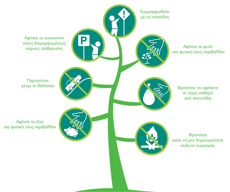
- Enjoy nature and leave it free of rubbish – don’t wait for someone “else” to pick it up.
- Don’t play with fire! The pine forests easily “ignite” and are not forgiving.
- Opportunity for a walk! Leave your car in the established parking areas and leave the other areas to nature.
- Choose one of the hotels or rooms for rental in the region for your accommodation. Free camping is not permitted because it is dangerous, especially for the forest!
- Turtles, finches and other animals species living in the National Park don’t want to move into your home – leave them in theirs.
- Some of the plant species living in the National Park are rare – photograph them but don’t cut them, they may be lost forever.
- Signs, information material and the Management Body’s personnel can provide information, so that your visit shall be enjoyable for everyone!
Good Conduct Guide
Institutional Framework
Law 3044/2002 established 25 Bodies for Managing Protected areas in Greece. This also includes the Kotychi – Strofylia Wetlands Management Body, which is a public utility Legal Person that is governed by Private Law and supervised by the Ministry for the Environment, Energy and Climate Change. It is governed by an 11-member Board of Directors whose composition ensures representation by central government (Ministries), local government at all levels (Regions and Principalities), the productive classes, the Environmental Organisations and the scientific community.
Lappa in the Western Achaia Municipality was designated as the Management Body’s headquarters, where its offices and the Strofylia Forest – Kotychi Lagoon Information Centre are located. Its area of responsibility covers an area of 14,300 hectares, which is distributed between the Achaia and Ileia Regional Entities. It is situated in the West to Northwest section of the Patras – Pyrgos Road, 18 – 50 km between the Municipalities of Western Achaia (Achaia Regional Entity) and Andravida – Kyllini (Ileia Regional Entity). The boundaries of the protected area extent from Araxos Cape (Achaia Regional Entity) to a short distance before Lehaina (Ileia Regional Entity) and include a 30 km long strip of land with a variable width from 0.5 to 4 km.
Purposes
The Management Body’s purpose is to protect the habitats in the protected region and specifically the wetlands, dunes and pine forest (Pinus pinea) at Strofylia – the most extensive pine forest in Greece. In addition to protection, the Authority’s aim is to provide information and awareness about the area’s ecological significance, to promote sensitivity amongst the citizens and to also implement environmental training, touring and ecotourism programs.
The Management Body’s priorities include recording and monitoring the types of habitats and the species of flora and fauna in the protected area, managing the forest to preserve and assist pine trees (Pinus pinea), continually monitoring the water quality in the lagoons, protecting dunes in the coastal zone and finally informing residents and visitors about the area’s values in order to raise their awareness about the dangers the region is facing.
Information Center
One of the most significant objectives of the Kotychi – Strofylia Wetlands Management Body is to inform the public and raise its awareness on issues relating to the protection of the natural environment, especially in relation to the National Park. The characteristics and the location of the protected area render it particularly significant to the biodiversity it exhibits, the natural resources, recreation, as well as agricultural – livestock production. All of the above lead to its intensive use by residents and visitors and raises a very important need for informing citizens.
Within this context, the Management Body has undertaken the operation of the Strofylia Forest – Kotychi Lagoon Information Centre, which is situated at Lappa in Achaia, approximately 4 km from the nucleus (Zone Α: Nature Protection Area) (hyperlink) of the National Park. The Information Centre is housed in an early 20th century building, a part of the Manolados I Royal Estate that has been defined as a “Work of Art” by a Ministerial Decision in 1982 (hyperlink). The building was reconstructed in 1995 by the Ministry for the Environment Spatial Planning and Public Works within the context of the ENVIREG Community Program under the “Environment” Enterprise Program, while its use was assigned to the Management Body in 2007 by the former Larisou Mayor.
Avifauna
The Kotychi – Strofylia National Wetlands Park is internationally significant for birds, which are amongst the most valuable elements of the natural environment and indicators of the ecosystems’ health, the condition of the various habitats to which they have adapted tolive, as well as the quality of life.
mongst the 442 bird species that are found in Greece, 261 have been observed in the area (approximately 59 %). 79 of these are species of priority for the European Union in accordance with Annex Ι in Directive 2009/147/ΕΚ (to date 79/409/EEC), while 40 species have been classified under one of the risk categories in the Red Book of Endangered Vertebrates in Greece.
The area’s importance for several breeding species is also extremely significant. 23 of the species that nest have been included in Annex Ι under Directive 2009/147/EC, which also includes globally threatened species such as the Ferruginous duck (Aythyanyroca) and the Common Kestrel (Falco naumanni).
Diversity in Space and Time
he huge diversity of habitats combined with other biotic and abiotic factors (climate, soil, etc.) are the main reason for the existence of a huge variety of avifauna species. This diversity becomes even more apparent between the seasons, whereby excluding the permanent residents living in the area, there are those that visit it during their journey to the northern (Spring migration) or southern (Autumn migration) areas, as well as those travelling to the area to nest or winter (hibernation).
Spring migration commences in February for species such as the ruff (Philomachus pugnax), glossy ibis (Plegadis falcinellus), garganey (Anas querquedula) and the black-tailed godwit (Limosa limosa) and continues until May or early June. It is a mass migration and more impressive than the Autumn migration with many species passing through in large numbers, including the black-winged stilt (Himantopus himantopus), little stint (Calidris minuta), curlew sandpiper (Calidris ferruginea), Kentish plover (Charadrius alexandrinus), garganey (Anas querquedula) and various Tringae like the marsh sandpiper (Tringa stagnatilis), wood sandpiper (Tringa glareola) and common greenshank (Tringa nebularia).
The most important species that migrate to the region for nesting, which highlights its value, include the little bittern (Ixobrychus minutus), purple heron (Ardea purpurea), garganey (Anas querquedula), short-toed snake eagle (Circaetus gallicus), Common Kestrel ( Falco naumanni), black-winged stilt (Himantopus himantopus), common pratincole (Glareola pratincola), little tern (Sterna albifrons), European nightjar (Caprimulgus europaeus), greater short-toed lark (Calandrella brachydactyla), etc. It is worth mentioning that in 2010, a pair of white storks (Ciconia ciconia) built the nest in the town of Metochi, which generated intense interest, since this was the first time in decades that the specific species had nested in the Peloponnese.
he period between November and February has been designated as the hibernation period in the region. Several species of birds migrate from northern Europe to the Mediterranean during this period to better source food. The onset of migration amongst the aquatic species varies in accordance with the species, while the size of the migrating populations is dependent upon the severity of the winter in northern Europe. The species that winter in the area include the common shelduck (Tadorna tadorna), northern pintail (Anas acuta), northern shoveler (Anas clypeata), Eurasian widgeon (Anas penelope), Eurasian teal (Anas crecca), common pochard (Aythya ferina), European golden plover (Pluvialis apricaria), northern lapwing (Vanellus vanellus), etc.
Furthermore, the number of species that live in the region all year round significantly increases during the wintering season and include the little grebe (Tachybaptus ruficollis), great egret (Ardea alba), grey heron (Ardea cinerea), mallard (Anas platyrhynchos), ferruginous duck (Aythya nyroca), western marsh harrier (Circus aeruginosus), common moorhen or swamp chicken (Gallinula chloropus), Eurasian coot (Fulica atra) etc.
Synopsis of the Ornithological Significance of the National Park
The Kotychi – Strofylia National Wetlands Park:
- Is located upon the imaginary Western migration route that follows the west coast of Greece from Albania to the Methoni peninsula (Messenia) and which continues for migratory birds by direct diffusion into the Mediterranean Sea or continues on to Kithira, Antikythira and Crete. With the exception of the “advance station” at Yalova lagoon in Pylos, Kotychi is the last and conversely the first in a series of significant wetlands of international significance along the western coasts of the Balkans from Dalmatia to the Southern Peloponnese (Neretva, Hutovo Blato, Skadar Lake, Drini Delta, Kalama Delta, Ambrakikos and Messolonghi).
- It is the only Wetlands of International Significance under the Ramsar Convention in the Peloponnese geographical district.
- The huge diversity of its wetlands and terrestrial ecosystems creates a unique combination in Greece that can accommodate a wide variety of bird species with different requirement (aquatic, woodland and migratory).
- The wintering conditions for the birds are favourable due to the mild winter.
- The wetland complex from Araxos lagoon to Kotychi is a natural continuation to the south of the very significant wetland complex of the Messolonghi, Aitolikon and Acheloos Delta wetlands.
- It hosts nine (9) different species of herons in large numbers throughout the year, of which seven (7) are priority species.
- It is one of the leading places in Greece for finding migratory wading birds, especially during spring and autumn.
- It is of National significance for the nesting of the little bittern (Ixobrychus minutes), which is found in the region’s extensive reed system and the purple Heron (Ardea purpurea), whose behaviour makes it difficult to observe it.
- It is an important nesting place for the rare ferruginous duck (Aythya nyroca), which is one of the nine (9) globally threatened species and one of the territory’s most significant places for the reproduction of the black-winged stilt (Himantopus himantopus) with its characteristic and noisy call, the common pratincole (Glareola pratincola) that nests in the open areas near the wetland system and the very small little tern (Sterna albifrons).
- The town of Lehaina is an observation point for a population of Common Kestrels (Falco naumanni), which nest on rooftops and holes in the walls. The Common Kestrel is one of the nine (9) globally threatened species.
- It is one of the best locations in Greece for the Marsh Harrier (Circus aeruginosus) during winter.
- It is an observation point for unusual European birds like the barn swallow (Hirundo rustica) and the Yellow Wagtail (Motacilla flava) that transforms the Kotychi landscape during winter with its yellow hues.
- It is a location where rare species like the Cream-colored Courser (Cursorius cursor), Cattle Egret (Bubulcus ibis) and Eurasian Dotterel (Charadrius morinellus) turnout.
Maps – GIS Applications
Welcome to the Web GIS Applications for the Kotychi – Strofylia Wetlands Managing Body.
You can navigate with the following applications:
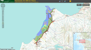
Navigating the National Park
Link: http://79.129.18.78/flexviewers/Periigisi_Ethniko_Parko/
Surf the National Park through our mapping application! Discover information on environmental aspects of the protected region, such as the types of habitats and follow our suggested biking and hiking trails through the Protected region.
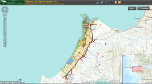
Pressures and Activities
Link: http://79.129.18.78/flexviewers/pieseis_drastiriotites/
Learn about the pressures that the National Park encounters through human activities and natural phenomena. Monitor the progress of implementing projects through the Managing Body’s opinions regarding land usage and authorised uses in the Protected and Wider Region.
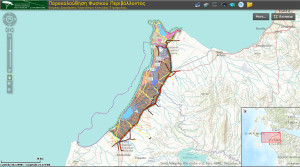
Monitoring the Natural Environment
Link: http://79.129.18.78/flexviewers/Parakolouthisi_Fisikou_Perivallontos/
Search for information and learn about the plants, animals and the types of habitats frequenting the Kotychi – Strofylia Wetlands National Park.
Sand Dunes
The rare and endangered dune habitat is encountered upon exiting the forest comprised of a mixture of Pinus halepensis and Pineus Pinea trees and travelling towards the coastal zone. The dunes are formed by sea sand that moves with the aid of the westerly winds and the Ionian Sea waves. This process provides them with their characteristic undulating shape in a north to south direction. The dunes occupy an area of 200 hectares and can reach heights of up to 10 metres and widths from 20 – 500 metres.
The dunes are a type of coastal habitat and play a significant role in the entire forest and wetlands ecosystem. They are a natural filter and flood barrier against salt water, which absorb the energy from the waves thus preventing the erosion of the coastal zone and providing protection to the wild fauna and flora. Plants that flourish on the sandy shores include the sea lily (Pancratium maritimum), Ammophila arenaria, Galactites tomentosa, which have adapted to cope with this hostile environment that is defined by strong winds with a high salt and sand content.
The wading birds nibbling on invertebrates and the endangered Caretta caretta turtle laying its eggs in the sand during the summer months are just some of the numerous species that nest, lay eggs and search for their food on the sandy shores.
The forest of Strofylia
The renowned Strofylia forest is situated in the north-western section of the protected region and is the most extensive Pinus pinea in Greece and one of the largest in Europe.
Strofylia forest has a total area of 2,200 hectares, covers a coastal forest strip with an average width of approximately 1,250 metres with small or large spaces and clearings. There is stagnant water with natural or artificial canals on its eastern and southern borders, which contribute in forming a sequence of wetlands (with fresh water and brackish water) and terrestrial habitats. This sequence creates an ecosystem with a huge biodiversity.
Strofylia forest is comprised of three dominant tree species, the Pinus pinea, the Pinus halepensis and the tame oak (Quercus macrolepis). The Pinus halepensis occupies the largest area and mainly appears along the sandy beach and dunes, while the interior of the forest is comprised of mixed clumps with the Pinus pinea as the dominant species. The Pinus pinea occupies a smaller area and is mainly found in the eastern section of the forest. Finally, the tame oak (Quercus macrolepis) occupies a very small area in the eastern section of the forest and appearing alone or in mixed clumps with the Pinus pinea.
The Pinus pinea that is known for its edible fruit is a sensitive species with restricted Mediterranean coverage. One often encounters it in the low lands near the sea, since it has a preference for sandy or sandy clay soils.
The greatest number of the Pinus pinea trees in Strofylia is found behind clumps of Pinus halepensis trees, which grow all the way down to the sea. This protects them from the strong winds and the salinity of the seawater. The majority of the Pinus pinea trees that are encountered in the forest are aged between 100- 200 years. The Pinus pinea has encountered natural regeneration problems in recent years and its reproduction is accordingly assisted with the planting of young seedlings.
Some of the other species that are encountered in smaller numbers are the wild pear (Pyrus amygdaliformis), Pistacia terebinthus, Juniperus phoenica, holly (Quercus coccifera) and the flowering ash (Fraxinus augustifolius). The forest does not have continuous shrubby undergrowth. It only develops at places where the forest canopy is broken according to the specific conditions and is comprised of species making up maquis vegetation or brushwood. Strofylia forest provides refuge for terrestrial turtles, foxes, weasels and tree mice together with many birds such as the cuckoo, long-eared owl, Phylloscopus, and others. Living and dead tree timber also provides a micro habitat for a variety of insects and mushrooms that play an important role in recycling forest matter.
Black Mountains
The Black Mountains are situated in the northern section of the protection region, below Araxos Lagoon and next to Prokopos Lagoon.
Their name refers to the characteristic black appearance of the vegetation from afar. They are comprised of compact limestone with traces of parent rock and reach a height of 240 metres.
Sparse oak tree forests (Quercus macrolepis) provide cover for the greater part of these hills together with evergreen – broadleaf undergrowth and brushwood.
The limestone rocks host endemic Greek flora such as the Centaurea niederi, which is only found here and the Kleisoura Gorge at Messolonghi. Mastic trees, junipers, wild olives, redbuds and wild pears are some of the typical shrubs growing on the Black Mountains while the Jerusalem sage (Phlomis fruticosa) is the frequently encountered brushwood. Intense grazing and summer bushfires ensure that the dominant vegetation is comprised of short shrubs, which increases the incidence of brushwood.
The Black Mountain limestone massifs are the main fresh water source for the forest while providing refuge for small mammals and reptiles, as well as nesting sites for birds of prey.
Wet Meadows
Open meadows of varying sizes spread out around the lagoons and marshes that are seasonally flooded. The meadows are dry during the warmer months and become a nesting habitat for rare species of birds like the collared pratincole (Glareola pratincola) and the little tern (Sterna albifrons).
Most of the meadows are totally or partially flooded during winter however and are accordingly considered to be an integral part of the wetlands. Vegetation varies in accordance with the unique soil characteristics, such as salinity content, the grazing regime and previous cultivations. Halophile species like the Salicornia sp. prevail wherever there are high salt concentrations and form an impressive crimson coloured vegetation mat during the autumn months.
Marsh Lamia
A little to the south of Prokopos lagoon one will encounter the Lamia marsh, which is a shallow swamp with an extensive surface area. Only one road separates Lamia from Prokopos and the two ecosystems communicate when there is heavy rainfall.
The marsh takes its name from a legendary creature that haunted it with its shrieking, until it was proven that these loud cries belonged to a nesting heron.
Some of the typical species of plants in the wetlands are the common reed (Phragmites australis), the bulrushes (Typha latifolia and Τ. angustata), and the willows and sallows (Salix sp.), while the giant cane (Arundo donax), Galingale (Cyperus longus) and sea rushes (Juncus maritimus) are frequently encountered.
Lagoon Araxos (or Papa or Kalogria)
Araxos Lagoon is situated on the borders of the protected region at the north-west edge of the Peloponnese.
It has an area of 450 hectares and an averaged depth of 0.5 – 2.5 metres.It is separated from the Gulf of Patras by an elongated sandy islet and extensive sand dune formations from the Ionian Sea. The waters here are brackish and have a higher salinity in comparison to the other wetlands.
Gulls and herons are the permanent residents of Araxos.
Lagoon Prokopos
Prokopos Lagoon is bounded to the north and extensive aquaculture takes place at Prokopos Lagoon.
Frequent visitors at Prokopos Lagoon are the coots, ducks, herons, waders and black winged stilts.
Lagoon Kotychi
Kotychi Lagoon is the largest Lagoon in the Peloponnese with an area of approximately 750 hectares and an average depth of 0.40 – 1.0 metres. It is situated to the north of the Lehaina region and is separated from the Ionian Sea on the west side by a narrow 5 kilometre length sand strip.
This is a typical Mediterranean Lagoon and is a significant site for the wintering, breeding and migration of water birds, many of which are in dwindling numbers in other regions of the country. In addition to the avifauna, Kotychi Lagoon is a significant migration site and habitat for various fish species until the reproductive period commences when they migrate to the sea. It is accordingly a natural vivarium that operates with traditional fish fertilisation methods.